
One heck of a view
By Dave Powell
For the TODAY
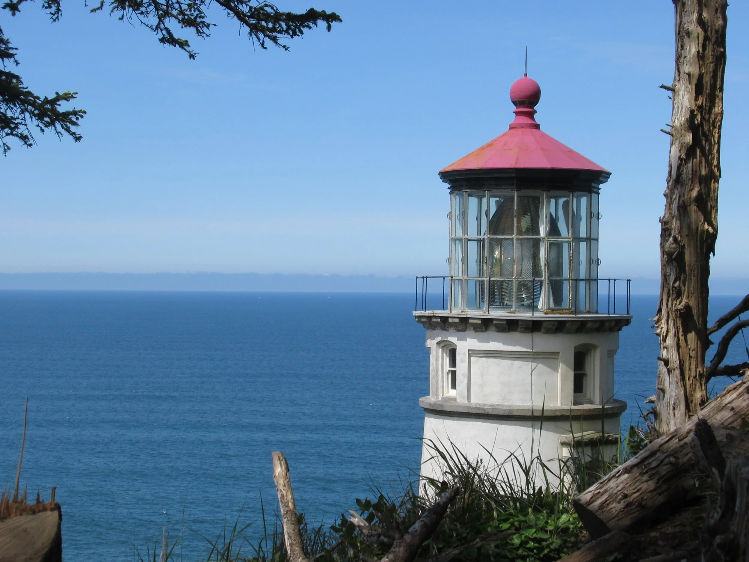
Heceta Lighthouse. What a pronunciation controversy! Is it HECK-a-ta or Ha-SEE-ta? During my years in Oregon I have heard it both ways. There was a glimmer of hope nearly two years ago when I attended a talk at the Hatfield Marine Science Center (HMSC) where the professor said both versions are correct! The pronunciation depends on whether you are talking from a naval or land-based position. Unfortunately, I didn’t have pen or pencil and paper in time to correctly set it out — and didn’t get close enough to ask afterward.So, of course, doing research for this article I contacted the Guin Library at HMSC. At best they can determine, “HECK-a-ta” is the local pronunciation. “Ha-SEE-ta” came with Californians who had a stronger Spanish influence. Was the professor just spinning a yarn? Which do I use? Whichever one I just heard the other person use.The light atop the 56-foot tower was first illuminated in 1894. Its automated beacon, visible 21 miles from land, is rated as the strongest light on the Oregon Coast.Heceta Head is named for Bruno de Heceta, a Spanish navigator and explorer, who surveyed the Oregon coast in 1775. The lighthouse was constructed between 1892 and 1893. In 1963, the Coast Guard gave Oregon the use of the lighthouse and surrounding property by the Coast Guard the same year that the lighthouse became fully automatedDevil’s Elbow State Park, which included a cove south of the lighthouse, was enlarged to include the lighthouse and renamed Heceta Head Lighthouse State Scenic Viewpoint. In 1998, the state department of transportation officially deeded the viewpoint to Oregon Parks and Recreation Department (OPRD). In 2001, the remaining Coast Guard property was transferred to OPRD. And, since it is so close to the Sea Lion Caves, I have occasionally spotted sea lions and harbor seals in the waters.For hikers getting to Heceta Lighthouse the route is fanciful. If you can time tides correctly, you leave Highway 101 at Ocean Beach Picnic Area (milepost 173.9), go down to the beach, and you can get around the southern promontory even at the higher of the two low tides (saving walking another 1.4 miles on Highway 101 to Muriel Ponsler). Otherwise continue walking to Muriel Ponsler (milepost 175.3), go to the beach, hang a left/south, go past BA 91, Washburne’s B-40 Trail (reopened this year), past BA 92, Washburne’s main access, and then another mile to BA 93, The Hobbit Beach. Go uphill on the Hobbit Trail. I haven’t seen any hobbits, but lots of small kids (this is an easy third-of-a-mile trail). Cars can park on Highway 101, which has an area on the left/east side about halfway up the hill. From the Hobbit Trail, you go right onto the Heceta Lighthouse Trail. It has a few muddy spots, several views of the ocean and beaches, and is a moderate difficulty trail of one and a half miles. At the end where it joins the path from the lighthouse to the B&B, detour to the right, the lighthouse is another 100 yards.The Heceta Lighthouse is said to be the one most photographed in Oregon. And its signals were very effective for mariners’ safety — if only it could help on Highway 101. What I consider the most dangerous part of the Oregon Coast Trail is within half a mile. I normally have gone through the tunnel when bridge work is done, the workers close one lane so I walk it. This year my wife, Pat, was driving behind me with the blinkers on. The tunnel is 0.14 miles — I ran it in just over a minute. Pat said that she held up two cars; I counted five on the car’s tail as I gasped for air.Some last notes:The gift shop is open 10 am to 6 pm seven days a week through Labor Day. The ice cream bars call to me.You can enter the lighthouse if volunteers are present. You can’t go up, they are protecting the Fresnel lens.On the trail near the gift shop and B&B is another large hedge of five-petal “Old Roses.”